Lars Nørings nettdagbok - Sydpolen
Lars Noring's South pole online diary
[noindex]
Ski the last degree to the South pole [mon 25.01.2010 01:02 (norwegian time)]
It's time for another expedition. The goal this time is to reach the geographic South pole by skis. I'm curently at a combined ski vacation and altitude training in Val Thorens in the French Alps. In two days I will head towards the southern tip of Chile. From there I will fly to Antarctica, and eventually be dropped off at 89 degrees south. From there I will, together with a group, ski the last degree to the South pole. The ski journey is estimated to take about 10 days.
The geographic South Pole is at about 2800 meter above sea level, of which 2700 meters is ice. But apparently it is supposed to feel more like 3800 meters.
I will post updates of the progress to this webpage. I can be reached through email at iridium noring.no. Questions, comments or just plain messages are welcome. (please don't send any pictures or other attachments as I'm using a slooow satellite link)

Never ending new year's eve [thu 31.12.2009 22:23 (norwegian time)]
I'm about to board a trans atlantic flight from Paris to Santiago, Chile. Since it is close to midnight December 31st and I'm flying west, this will be the longest new years eve ever. As 2010 arrives around the world from east to west, I will follow, celebrating the new year over and over and over again. I will be able to celebrate the new year in all the 5 time zones between France and Chile!
[warning! science paragraph that spoils some of the fun] Unfortunatly this is not the case. It will be january 1st long before I reach South America. If I were going directly west from Norway, it would be possible to "follow the sun", or in this case follow midnight, around the world in an commercial airliner doing about 800 km/h. But I'm leaving from Paris where the earth is much wider. In addition we're flying quite a bit south as well, makeing the movement west even slower. When we are crossing equator, the earth spins at a spead at about 1600 km/t. So we'll lose the midnight quite fast.
But there is a good chance that I will celebrate the new year twice. Once in the French/Norwegian time zone and once in the British :).
Happy new year! Happy new year!

Longest journey [fri 01.01.2010 23:19 (norwegian time)]
After traveling for 34 hours I have finally reached my hotel in Punta Arenas, in the south of Chile. The picture of the day is of the hotel, Condor de Plata. It is a simple hotel, but the walls of the lobby is plastered with greetings from various expeditions that has stayed here.
I got to celebrate the new year 3 times last night! Since Paris is so far west and really ought to use GMT+0 rather than GMT+1, we managed to have midnight in three different timezones. But for some unexplainable reason I was the only one sitting with a watch and GPS celebrating over and over again. The rest of the passengers where content with some champagne and cheering the first time and all went to sleep. Ignorant party poopers.
Other than that the trip was rather uneventfull. Except I learned that even though you treat yourself with a 1st class train ticket in France, you might end up sitting on/in the luggage rack, as they don't keep track of how may tickets they have sold.
Since I made all my connecting trains and flights (only by an inch in Santiago) and didn't loose any luggage, I now have a couple of slow days in Punta Arenas. It all depends on the weather. There are often delays or early departures, but I expext to leave for Antarctica in 3 days, on January 4th.

The windy city [sun 03.01.2010 00:53 (norwegian time)]
Punta Arenas means sandy point. But they should have called it windy point or windy city. Today there were winds of gale force (19 m/s, sterk kuling). I'm guessing the gusts was of storm force. It didn't rain, but if you didn't pass by water pits on the right side, you were sure to get wet. The average wind force during summer (now) is said to be about 10 m/s.
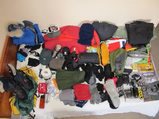
I've spent the day walking around seeing the city and going over my clothes/equipment. Most of it is spread out over my bed in the picture.
The time zone here is GMT-3 during the summer. So I'm 4 hours behind Norway. If I write an entry at 20:00, it will be midnight in Norway. Since this is our jump off point to Antarctica we will follow this time zone when there as well. The sun only raises and sets once a year on the South pole, so you can pretty much choose your own time zone. And usually the choice is the same as the time zone of the place you fly in from. Unfortunatly the americans at the research station at the South pole fly in from New Zealeand, so they follow GMT+13.
Ready! I think... [mon 04.01.2010 02:26 (norwegian time)]
Another relaxing day. My two bags have been loaded onto the plane. Now we are just waiting for good weather. We will probably leave tomorrow morning.
What have I forgotten this time? On the north pole trip I managed to forget a recharging cable at the hostel at Svalbard. The consequence was, among other things, that we had to limit the number of uploads of pictures during the trip. I've checked, double checked and tripple checked that cable this time.
(I know, a cable sounds like the least important thing on a trip like this. Clothes and other equipment are much more essential. But to an old internet geek, a forgotten cable is like a small traumatic event)
The waiting game [tue 05.01.2010 02:58 (norwegian time)]
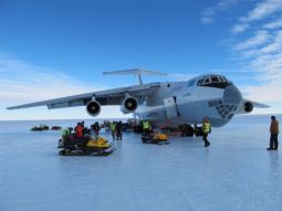
Today we were supposed to fly out to Patriot Hills in Antarctica at about 80 degrees south. We are (hopefully soon) flying with a russian top-winged 4 engine Ilyushin 76. It's much bigger than the Antonov 72 used from Svalbard to Barneo in the north. The Ilyushin has wheels and lands on a blue ice runway, unlike the much smaller planes used in the interior of Antarctica that has skies.
But the weather at Patriot Hills hasn't been good enough for flying. So we are waiting. We are getting periodicly weather updates. Long delays of several days are not uncommon.
Waiting isn't all bad. I had dinner at a nice restaurant with 3 others today. A guide who has just finished an all the way trip, the base camp manager on a week off and a Brit who is on his way to climb Mount Vinson. Great company and great local food and drinks. (well almost, I guess for instance that the creme brulette dosen't count as local food)
So now it's another night at the hotel. But tomorrow...
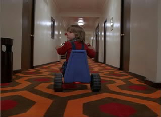
redrum [tue 05.01.2010 20:05 (norwegian time)]
All wait and no plane makes Lars a dull boy. All wait and no plane makes Lars a dull boy. All wait and no plane makes Lars a dull boy. All wait and no plane makes Lars a dull boy. All work and no play makes Lars a dull boy. All wait and no plane makes Lars a dull boy. All wait and no play makes Lars a dull boy. Aoa wait and no plane makes Lars a dull boy. All wait and no plane makes Lras a dull boy. All wait and no plane makes Lars a dull boy. All wait and no plane makes Lars type this on his tiny keyboard.
Antarctic [wed 06.01.2010 06:37 (norwegian time)]
After a 36 hour delay, the plane took off from Punta Arenas. Then 4.5 hours later, we landed at Patroit Hills. It's 2:30 in the morning, so time to sleep.
Patroit hills [wed 06.01.2010 14:22 (norwegian time)]
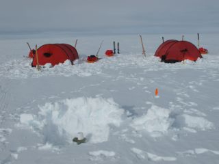
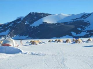
Patroit hills is an incredible place. To the south I see the Patroit Hills moutain range, and just in front of it the big runway. To the north I see a white endless field. And here in the middle of this a cluster of various sized tents. The biggest is the kitchen/eating tent which serves 3 meals a day. There's a medical tent, 3 toilet tents, a communications house/container and a bunch of sleeping tents. There are 2 kinds. The smaller private mountain tents for the staff and the bigger clam tents for guests when staying at the base. I share my tent with Tom, an American who is also going to ski to the south pole. But we could easily have fitted 5 or 6 persons in here. And I can stand up straight in the middle of the tent.
Patriot hills is an entirely commercially run operation. It was initially set up for people that wanted to climb Mount Vinson, the highest peak in Antarctica and the last of the 7 summits. But now they are supporting many South pole expeditions as well.The camp only exists for a couple of months during the antarctic summer.
The camp is located at 80 degrees north and 81 degrees west, straight south of Chile. It's on a glacier 800 meter above sealevel. The weather today is scattered clouds and about -10 degrees C. I guess warmer than Oslo at the moment. But I'ts a windy place.
Patriot hills 2 [thu 07.01.2010 02:24 (norwegian time)]
The first day at Patriot hills is over. As some of you have mentioned, it is of course located at 80 degrees south and not north. Today we have been introduced to camp and received and tested equipment we are renting. Like tents, skies and stove.
We will go for a overnight trip in the area tomorrow.
The picture shows a clam tent to the left, the staff tent village in the middle and the Patriot hills in the background.

Test run [fri 08.01.2010 18:05 (norwegian time)]
On an oveernight trip around Patriot hills. Camped on the other side of the mountains than base camp after a 17km skitrip.
Great weather. Sun and just a little bit of wind
89 degrees next [sat 09.01.2010 01:31 (norwegian time)]
Back in base camp from the small trip. We will leave for 89 degrees tomorrow to start skiing towards the south.
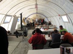
The picture is of the mess tent. The eating area in the front and the kitchen in the background. To the left in the kitchen in blue is Malin, the norwgian chef. (Skal hilse fra henne, Espen). The food here is great, just like at a nice hotel and not at all what you would expect at a tent camp in the Antarctic.
89 degrees! [sun 10.01.2010 04:09 (norwegian time)]
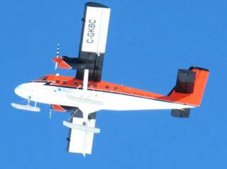
The Twin Otter had to do a short run to Mount Vinson first today, so we had to wait a bit before getting flyed to 89 degrees. But now we are her! They dropped us off at 88 degrees 59.2 min south and 95 deg west. We skied 1.5 km to 89. We are at 2800 meter above sea level, so it's important to take it slow the first days.
The temperature is -27C. It's sunny and 3 m/s of wind. There is a 2 cm soft snow layer we are skiing through.
The picture is of the Twin Otter as it takes off. It has been fitted with skies so it can land on snow. Now we are left to our self. Nearest human (or any life form) might be 1 degree away, or 111km. We have food and fuel for 10 days, but expect to be at the pole within 8 days.
With me are Tom from Texas and Stephan and Patrick from Switzerland. They are father and son. And finally there's Rob. He is a mountain guide on his first trip to the South Pole as well. They are a great bunch to travel with. A god mix of people.We are bringing two Helleberg tents. I'm sharing one with Tom and Rob.
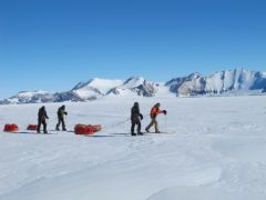
Camp 2, 89 degrees 4.6 min south [mon 25.01.2010 01:02 (norwegian time)]
Today we've had half a day of slow skiing getting acclimatised. We covered about 8 km. There's been a thin layer of clouds all day, but I could still navigate by my shadow (and watch) most of the day.
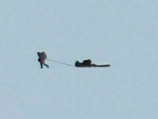
As you can see on the picture there's nothing out here to look at other than ourselves and the wast endless almost totally flat fields of snow.
It was a bit cold this morning, but as we set up camp it was around -20C and only a couple of m/s of wind. The 24hour sun warmes up our tents. There are almost no need to heat it with the stove. Depending on clouds the inside of the tent is between +10C and -10C. The barometric pressure is 696 mb.
We are all doing well. Tom says hello, Cathy. Thank you for the emails.
As a reminder, the address that can be used for sending short messages is iridiumnoring.no.

Move along, nothing to see [tue 12.01.2010 00:12 (norwegian time)]
Today has been a relativly hot day,about -18C. There has been a thick cloud cover, so no possibility of navigating by shadows. Most of the time we could see the sun, only just. But as it is behind us all day, it's not practical to navigate after.
There was little wind today, but I was navigating by the marks the wind has made in the snow. The provailing wind direction in the area is about 45� towards us on our left side.
Rob is getting the bearing with his gps/compass and getting a fix on a point in the distance and skiing towards it. It's quite difficult in this monotone landscape, but he is doing it flawlessly.
The landscape consist of loong very low waves/dunes of snow. On top of them there are smaller shapes and forms in the snow (sastrugies). But they are not big enough to cause us any problems. The snow is a bit harder now, and we are only skiing throug a small cm of soft snow.
We got fog about halfway into the day. At one point we almost got white out That made it hard to navigate, both for Rob and me. We used the GPS and compass a lot more during that period.
The altitude sickness troll visited us today. One of us (ikke jeg) got an altitude headache. But it seems to have passed now.
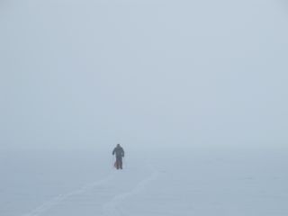
We stoped after 7 hours to set up camp. We've skied about 16 km and are now at S89�13' W95�22'. Only 46 nauticle miles to go.
Broken ski binding [wed 13.01.2010 00:35 (norwegian time)]
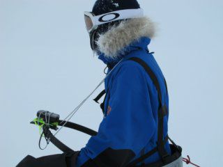
This has been another good day to ski. About -18C and not much wind. But it has been a difficult day to navigate as it has been foggy all day. Bad visibility and contrast. So today I put on a GPS harness. It keeps the GPS a foot from my chest, so I can just look down on it (picture). Almost a necessity when you loose all other visual references.
Patrick is btw the one in the picture from yesterday.
The binding on Tom's right ski broke today. Luckily we have a pair of spare skies with us. We'll also try to do a temporary in the field fix tonight.
I'm using regular Fisher mountain skies with steel edges, half skins (korte feller) and nordic bindings (gode gammeldagse rottefella bindinger med 3 tapper du setter fast skoene i). I have Alfa M�rdre Pro ski boots. Except for Rob the others have enormous boots. Looks like astronaut boots. So they are using bindings that just fasten theire lunar boots to the skies with a couple of straps. Half of them are using a bit shorther �snes skies with full skins and the other half even shorter and wider skies, also with full skins.
We skied for 8 hours today and are currently at S89 deg 22 min, so we are well over 1/3 of the way.
Thank you for all your messages through facebook and email. Tom sends his regards to Kristin, Kevin, Connor and Regan.
Navigating by the poles can be tricky [thu 14.01.2010 01:58 (norwegian time)]
Great day to be skiing today. Sun, almost no wind and -20C. Good day to be navigating as well. Tom, Patrick and Stephan took turns heading the group and navigateing by the shadow.
But navigating close to the poles can be quite difficult. Today we came across an old track going 45 degrees to the right of our course. Where were they going?
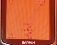
My theory is [warning, science content paragraph] that they did a mistake with theire GPS. The earth is a (almost) sphere. But maps are flat. The classic example from school is to peal an orange, and try to make it flat. This is what makes Norway look extremely big and India extremely small on a world map. This "problem" is very noticable down here. We are not aiming directly for the pole. But at the edge of a large antenna a couple of miles out, that we have to go around. The antenna is at about W121 deg and we are at W95 deg. So if you use the GPS to navigate, and looks at it's map, it will send you in the wrong direction. Picture number 1 shows the path we have Been going in blue and the path to the antenna in pink. But if you switch the GPS to navigation mode, it will send you in the correct direction, almost straight south. This is only a problem because we (and they) are on another longitude than the antenna.
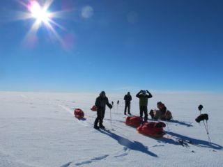
We reached 89 deg and 30 min today, which is halfway to the southpole. The second picture is when we reached 30 min and stopped for lunch. The day consist of 50 minutes of skiing and a 10 minute break (hour-minutes, not to be confused with degrees-minutes). Then repeated 8 or 9 times. During the break we have a short lunch/snack, a bit of water and do changes to our clothing and so if needed. So we have lunch 7 or 8 times each day. I drink 2 dl of water each time. To eat we have chockolate, energy bars, salt sausage, cheese, shot blocks (a kind of energy gel), biscuits and a nuts/raisins/dried fruit mix.
To all of you that have emailed your concern about Tom's broken binding. He has fixed it, and it is even better than before.
We are currently at camp 5 at S89 deg 34 min. Only 26 nauticle miles to go. (pluss some extra miles to go around the antenna and cross the runway at the correct place).
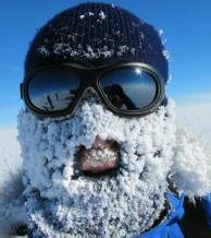
The last picture is of me, how I looked at one of the lunch breaks
Again, the weather today was (is) great. After we set up camp, I walked around for a bit taking pictures. But I think I 've uploaded enough pictures for one day.
Ms Meagan I presume [fri 15.01.2010 01:46 (norwegian time)]
This morning started with snow and 3 m/s of wind and ended with about 6 m/s There was fog all day and the new layer of snow removed all visual marks on the ground. The small sastrugies are still there, but you don't see them So my skies have been going up and down without prior notice all day.
Rob and I took turns in leading the group and navigating. Again we used a GPS straped to a harness.
2 hours into the day we became aware of a single skier approaching from the rear. It was most likely Meagan McGrath. She has been going unsuported all he way from Herclues, which would be the sea if it hadn't been for the ice. Well, except from a couple of days into her trip where she fell into an cravasse (bresprekk) and needed rescue. Luckily she got a satellite-signal on her Iridium from down in the cravasse.
Anyway she crossed our tracks about 1 km behind us. She kept on going at somewhere between 30 and 60 degrees to our direction. Might look like she is having a GPS- or some other navigation-problem as well. I'll probably get a chance to ask her about it at the pole. (or perhaps she just didn't want to meet anyone at that point and went around us). The first picture is of her before she disappears into the fog. (thank you optical zoom and a dozen megapixels (actually only 10, as they decreased it in the Canon G11)).
The second picture is of our camp a couple of days ago. In the front you can see our penguin traps. Haven't caught any yet though. But the holes have other uses as well. They are always dug downwind from the tent. To the right of the little orange marker flag is the small hole. That one is used for pee. (sorry, I don't know the propper/approperiate english words for these kind of things). We either pee straight into the hole or empty our night bottles. When we leave camp, we just fill in the hole with snow.
I guess you understand what the other hole is for. It is a bit bigger so we can walk down into it. There is also a small wall to shield from the wind and nosy neigbours. We have these special bags, called wag bags, that we do it in. Then we bring the bag with us. It isn't as bad as it sounds, as everything freezes solid rather quickly. The trick of course is to be fast enough, so you don't get frostbite or your leg cramp up so you tip over.
I forgot to mention the who is who on the halfway picture yesterday. From the left: Patrick, Stephan, Tom and Rob (sitting down on his sledge (pulk)).
Today we skied for 8 hours. It takes us about 30 min to set up camp. First we have a soup or noodles before dinner. In addition to freezdried food, we have brought a lot of frozen food prepeard by the chefs at patriot hills. We have excellent dinners, and usually a piece of cake.
After dinner we have some hours before we go to bed to chat, read, report our position back to base, write our hardcopy or online diaries or whatever maintance or other stuff that needs to be done. We are all getting good nights sleep. In the mornings the alarm clocks are set to 7am, 2 hours before we leave. That is plenty, so we have slow mornings. Today we even left 10 min ahead of schedule.
Camp 6 is located at S 89 deg 43 min, W 96 deg. Only 17 nauticle miles from the pole (but remember we have to do a detour around the antenna and air sttip). If all goes well, we'll be able to see the pole in the distance from camp 7.
(btw, there aren't any penguins as far south as this)
South pole in sight [sat 16.01.2010 01:38 (norwegian time)]
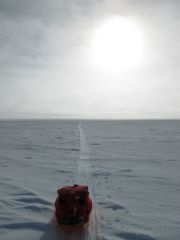
This morning started with 5 m/s, clouds and about -20C. The visibility and contrast was back. We could again see the sastrugies and navigate by them (and GPS). Rob and I took turns in navigating today as well. During the the day the wind and clouds disappeared. The first picture is taken back towards north while skiing today. You can see my sledge and our track.
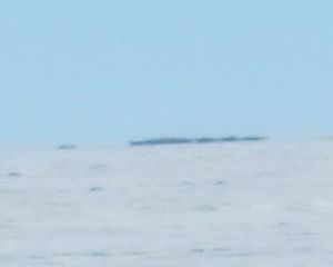
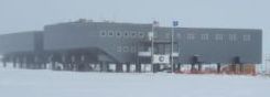
At S 89 deg 51 min we spotted something big and white in the horizon. (well, "big", from that distance we could barely see it). After another minute (of a degree) we saw some more buildings. Or at least what we assume are buildings. At S 89 deg 53 min we saw a building moving quickly to the right before it suddenly went up into the air. The plane flew around the south pole for quite some time before we lost track of it. The second picture is of the main building at the South pole, the US Amundsen-Scott research station. This evening we saw a big Hercules aircraft land as well.
We are currently camped at S 89 deg 53.8 min W 102 deg, only 6.2 nauticle miles from the South pole (11 km). But as previously mentioned we have to do a little detour at the end.
In the last picture you see Rob (to the left) and me. Rob is calling in our position back to Patriot hills while I'm uploading pictures.
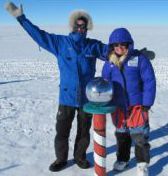
South Pole, S90 degrees [sat 16.01.2010 20:05 (norwegian time)]
We reached the South Pole, S90 degrees, today January 16th 2010 at 1700 norwegian time (1pm chile time, 5am new zealand time (17th)). The weather is great with sun and only blue sky, -25C and 4 m/s wind.
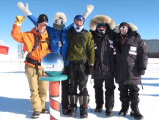
The picture is of us at the seremonial pole as we arrived. From left Rob, Lars, Tom, Stephan and Patrick. Meagan took the picture.
We have camped 100m north (!) of the pole
More to come...
South pole pictures [sat 16.01.2010 23:55 (norwegian time)]
Just quickly uploading some pictures. We are about to have Patrick, Stephan and Meagan over for dinner at our tent.
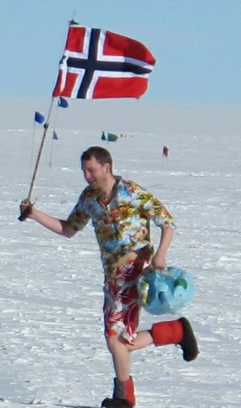
The first picture is me running around the world, just after tossing my beach ball. For those not familiar with the ball, can have a look at www.youtube.com/lnoring.
The second picture is of Meagan and me at the seremonial pole.
The last picture is of me at the actual geographic sout pole.

Morning at the South Pole [sun 17.01.2010 17:11 (norwegian time)]
I'ts morning at the South pole. But really, what is morning here? The sun is the same height during all day and night. It only sets once a year, about 21st of March (vaargjenndoegn, eller hoest her da) and dawns about 21st of September. As previously mentioned, when you are in Antarctica, you usually choose the time zone of the place you fly in from, for practical vand logistical reasons. So wa are at chilenian summertime (gmt -3).
The Americans at the enormous Amundsen-Scott research station at the south pole are at New Zealand summertime (gmt +3). So when they invited us to a tour of theire main building at 6pm. That ment 2am for us. We weren't back until 4am. The station have about 150 beds in the main building and a bit less in the summer camp. At winter they are 42 (this year). Staying during winter is a long term comitment as they suspend flights for about 8 months.
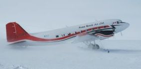
We will be picked up by plane at 2pm today and flown back to Patriot Hills. This time it will be a Basler, an updated version of the DC3 with a tail wheel. This plane is also fitted with skies and can land just about anywhere in heavy wind. From Patriot Hills we will be flying back to Punta Arenas, Chile, as soon as the weather permits. I'm scheduled to leave Chile with Air France on the 19th (landing in Europe on the 20th), but it is by no means certain that I will reach that flight.
Thank you for all your greatings. I have forwarded the ones for the others. We are all doing great. We are thrilled to finally being here after traveling with skies and sledges for 60 nm (111 km) for about 7 days. Actually it is a little bit longer as we had to detour around a bit getting close to the research station and the fact that I'm sure we didn't manage to keep a perfectly straight line. I'm eager to stidy our gps track when I get back.
There are 2 "poles" here, the ceremonial pole, that usually stays in the same place, and the real pole that is moved each year as the ice under us moves about 10 m per year. They are currently about 50 m apart.
[warning, science paragraph] As I found out before the North pole trip in 2008, the poles are not fixed at all. The earth wobbles quite a bit, so the north and south pole which are the point of the earth surface that intercepts with the axis of it rotations, moves constantly. I'll cut this paragraph short as not many besides me cares about it. Here they just move the marking for the geographical pole on the ice once a year (jan 1st) acording to WGS84.
Unfortunatly the place on the ice that Amundsen (and later Scott) reached has moved (because of ice drift) about 1 km into what is now known as the quiet sector. W can't go there because of the research being done. We are currently at about 2800 meters of which 2700 meter are ice.
Did a typo on picture of Meagan and me yesterday, so the first picture is a rerun of that one.
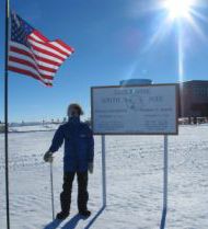
The second picture is of my GPS at the WGS84 geographical south pole.
The third picture is of the dinner party last night. From the left: Meagan, Tom, Rob, Patrick and me. Unfortunatly Stephan was just outside the picture on the far left.
The 4th picture is of our camp at the South Pole with the research station in the back. The seremonial pole is just in front of the right part of the building and the geographical is to the left.

Back at Patriot Hills [mon 18.01.2010 05:54 (norwegian time)]
The weather this morning at the South Pole, acording to some scientists that came and visited us, was -26C and 5m/s of wind. There was a thin cloud cover. These scientists was working on the "icecube", a neutrino telescope that detects neutrinos that has entered on the other side and travelled through the earth. The telescope faces down,consists of maaany detectors and goes as far as 2500 down into the ice. (I didn't warn about a science paragraph, so I'll better stop here).
The first picture is of the door as we went into the building of the research station yesterday.
The DC3 picked us up abot 3pm. The second picture is of the plane as it taxes from the runway and all the way up to our tent site.
The third picture is the last picture from the South pole taken out of the window of the plane as it takes off. The whole building is standing on huge pillars. All previous buildings has eventually been buried in the snow. The well known dome, the old main building, was taken down just before we arrived. The pillars of the new building has two purposes. First so the wind and snow can go under it and not pile up against it. Secondly, when the snow finally catches up to the building, they can just raise it by extending the pillars.
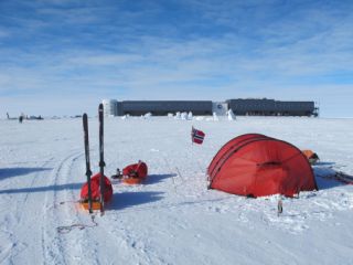
We are now back at Patriot Hills. The 4th picture is a new attempt on the picture of the tents and mountains. We had a superb celebration dinner in the mess tent when we got back. There has been some strong and unstable winds here lately, so we might be delayed out of here. But that doesn't matter. It is a great place to be. We'll know more tomorrow.
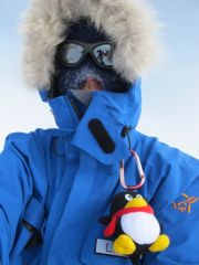
I finally got a penguin! Last picture. Shame on those of you that made fun of my penguin traps.
Going home [tue 19.01.2010 01:01 (norwegian time)]
Today has been a day of waiting for better weather for flying. But I've kept busy being around camp helping out where needed.
This evening the meteorologist found a small window of acceptable weather, so we are leaving tonight. This means I'll get my original flight from Punta Arenas to Santiago, just. So I'll go straight from a tent camp in the Antarctic to Oslo, changing plane 3 times. I hope to find a place in the airport in Punta Arenas to change clothes and clean up a bit. I'll reach Oslo, from Paris, wedensday afternoon if I remember correctly.
I'll be sad to leave this place...
Epilogue [fri 22.01.2010 00:43 (norwegian time)]
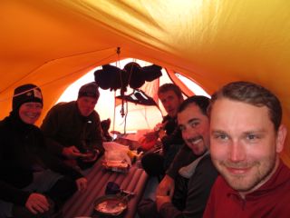
I left Patriot Hills monday evening. Arrived at Punta Arenas a little earlier than first planed, so I got on an earlier flight to Santiago. In Santiago I took a shower and relaxed a bit before I boarded Air France flight AF401 to Paris. We taxed out to the runway, the pilots gave full throttle and we accelerated down the runway. Just as usual... untill there was a loud BANG. The pilots hit the breaks and we screeched to a halt. There is less than 8 months since Air France Flight AF447 vanished on its way from South America to Paris. 228 people died. After standing a while in the middle of the runway, we limped back to gate. There we waited again for a while before we evacuated the plane. And then we waited again for a looong time.
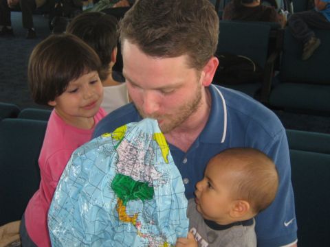
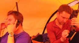
This could easily have become another "All wait and no plane makes Lars a dull boy". But luckily I was seated next to a mother and her two small children (6 months and 4 years). We joined forces. She had a lot of luggage in addition to the two childeren. So I helped her out looking after the childeren and carrying the luggage. Late in the evening we got bussed out to a hotel (separate rooms). The following morning we got bussed back. But as other passengers might have been stressed or bored out of theire minds, we were having fun playing (picture).
21 hours late we boarded a new plane, AF401A. Next to it we saw the old plane. It was apparently still broken. They never told us exactly what was wrong. First they announced they wanted to check the wheels. Then they mentioned the engine. From rumours and people having a view of the left engine, I was told that there was flames out of the engine. It has also been said that it stopped for a bit just before the bang. Aparently technicians began checking it out and shrugging theire shoulders while we were still on the plane.
The flight from Paris to Oslo was uneventfull. Now, thursday night, I'm finally home at about 60 degrees North. I guess it will take me a couple of days to sort through pictures and video clips. The journey home from the South Pole took 4 days and crossed 150 latitudes in 5 different air crafts (well, 6 if you count the one we broke).